Why Polygon Mapping is Necessary for EUDR Compliance
Polygon mapping and EUDR
Imagine you're a coffee exporter. You’ve heard about the European Union Deforestation Regulation (EUDR), which demands proof that all commodities are sourced from deforestation-free areas. For commodities like coffee, rubber, and soy, this compliance isn’t just another checkbox; it’s essential for accessing global markets.
The challenge lies in how to accurately verify this compliance because identifying doesn't solve the problem. You have to be able to prove that your products are legally sourced plus comply with all the EUDR guidelines. This includes maintaining proper data on the supply chain, analysing risks and a plan for mitigating these risks and presenting proper data along with the proofs, in the form of a Due Diligence Statement (DDS). One of the important factors in this is tracing the land from which the commodity was produced and is it deforestation-free.
Enter polygon mapping, a geo-fencing technique that lets companies track products back to specific plots of land. This process not only helps identify sourcing locations but also mitigates risks associated with deforestation, ensuring that goods come from responsible and sustainable sources.
Polygon mapping can play a critical role in achieving EUDR compliance. From understanding its basics to its applications in the supply chain, let’s explore how technology can make a difference.
Understanding Polygon Mapping and Geo-Fencing
Polygon mapping and geo-fencing are essential tools for ensuring that commodities like coffee, rubber and other commodities that come under EUDR regulations are sourced from compliant, sustainable areas.
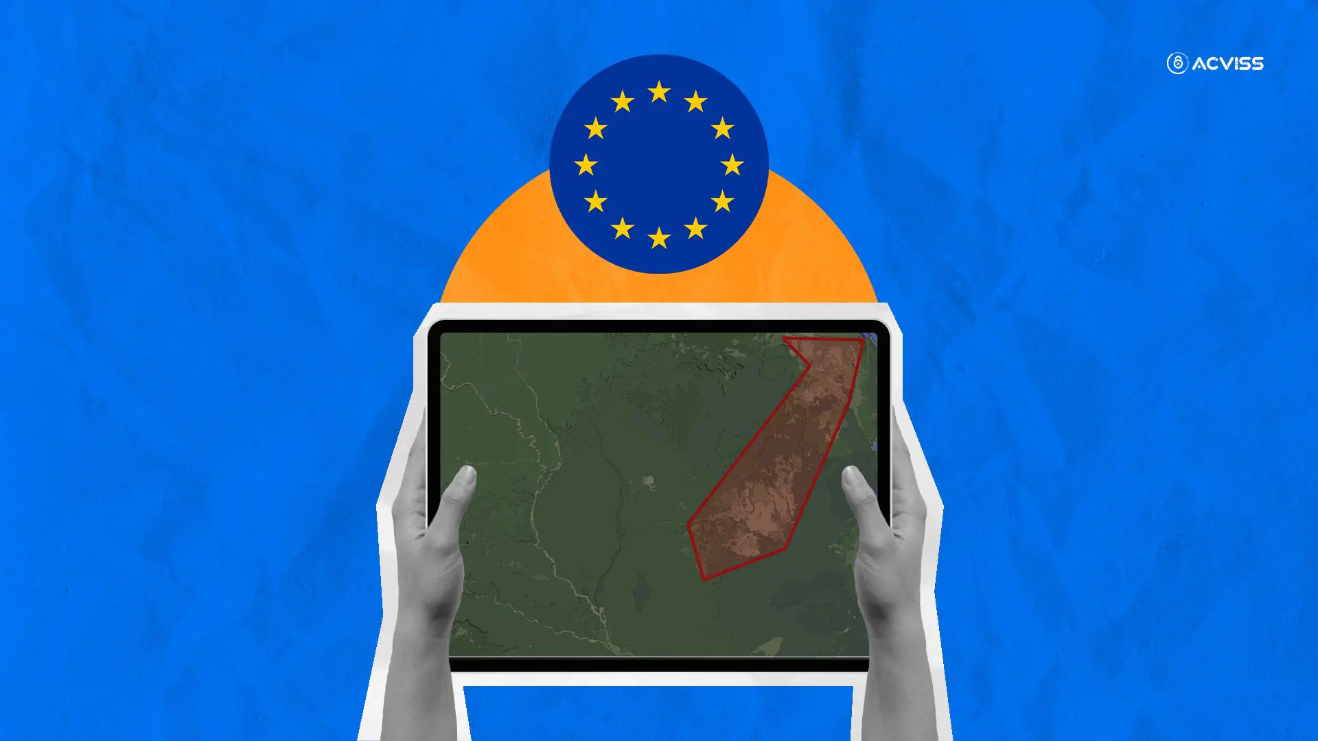
So, what exactly is polygon mapping? In simple terms, it’s a digital technique that uses satellite data to outline and monitor specific areas on the Earth’s surface. Imagine a virtual boundary drawn around a farm or plantation. This is the “polygon” that can be tracked and analysed.
Geo-fencing, on the other hand, leverages this mapped data to create a virtual perimeter around these areas. Whenever a product is linked to a specific piece of land, geo-fencing ensures that it doesn’t cross into unapproved or deforested regions. This is particularly vital for the EUDR, as it helps prove that sourcing follows legal and sustainable practices.
In practice, both tools work together to confirm that commodities are grown on deforestation-free land. By tracking land use and changes over time, companies can ensure compliance with EUDR regulations and avoid any potential penalties or market restrictions. This approach also reassures consumers about the authenticity and sustainability of the products they’re purchasing.
How Polygon Mapping and Geo-Fencing Support EUDR Compliance

Polygon mapping and geo-fencing offer crucial support for businesses aiming to meet EUDR compliance standards. Here’s how these technologies make a difference:
1. Accurate Land Monitoring
Polygon mapping provides precise data on land use and changes, helping to verify whether commodities like coffee and rubber are sourced from areas free of deforestation. This is essential, as EUDR regulations require proof that products are not linked to illegal deforestation.
2. Enhanced Traceability
By defining and monitoring specific areas, geo-fencing ensures that commodities remain within approved boundaries. It allows companies to track the entire journey of a product, ensuring it only moves through compliant regions. This traceability is vital for EUDR compliance, as it helps maintain transparency and provides a clear chain of custody.
3. Preventing Fraud and Mislabeling
Geo-fencing helps protect against false claims by verifying that commodities genuinely come from sustainable sources. This reduces the risk of mislabeling, ensuring that only legally and sustainably sourced products enter the market.
4. Reducing Compliance Costs
By using automated systems to monitor land use and track supply chains, businesses can reduce the need for costly manual inspections. These technologies can detect changes in real time, allowing companies to respond quickly to any potential issues and maintain compliance more efficiently.
Incorporating polygon mapping and geo-fencing into supply chain management not only helps meet EUDR requirements but also reinforces a company’s commitment to sustainable sourcing, which can enhance brand reputation and customer trust.
Using Polygon Data for Supply Chain Integrity
Polygon data plays a vital role in strengthening supply chain transparency and traceability, especially under EUDR compliance. By mapping out precise geographical areas and tracking changes over time, businesses can monitor where their commodities, such as coffee and rubber, are sourced. Let’s understand this with examples.
- Example 1: Coffee
For coffee exporters and producers, polygon data can ensure that farms are not located in deforested or protected areas. By overlaying polygon data onto satellite imagery, companies can confirm that coffee is grown sustainably, providing verified evidence for compliance reporting. - Example 2: Rubber
In rubber production, polygon mapping helps trace the journey of raw materials from plantation to processing. This data offers insights into land use changes and confirms adherence to sustainability practices, which is crucial for EUDR compliance.
By integrating polygon data, companies create a more transparent and verifiable supply chain. This technology enhances accuracy in verifying sourcing practices, which is fundamental to reducing environmental impact and maintaining compliance with global sustainability regulations.
Role of Blockchain in Enhancing Polygon Mapping for EUDR

Blockchain integration in polygon mapping not only secures data but also streamlines compliance with EUDR regulations through several unique benefits:
1. Immutable Data for Accurate Compliance
Each entry in the blockchain is immutable, meaning that once data regarding the origin, size, and location of a farming polygon is recorded, it cannot be altered. This feature ensures that the geographical footprint of each commodity remains accurate over time, which is essential for tracing back to verified, non-deforested areas.
2. Boosting Supply Chain Trust
Blockchain technology brings all stakeholders—farmers, exporters, regulators—onto a single, transparent platform. For example, rubber or coffee producers can directly input location data that is then visible to downstream partners, boosting trust across the supply chain and ensuring alignment with deforestation-free practices.
3. Enhanced Verification through Smart Contracts
Blockchain can employ smart contracts to automate compliance checks. For example, if a new polygon is added to the map for a coffee farm, a smart contract can automatically verify that the region is not deforested. This streamlined process reduces manual checks and ensures instant compliance validation.
4. Linking Polygon Data with Supply Chain Events
Blockchain facilitates the connection between polygon data and other events within the supply chain, such as shipment and processing. By maintaining a unified, traceable record, blockchain enables businesses to provide regulatory bodies with a full audit trail from farm to export, showcasing their adherence to EUDR.
Overall, blockchain not only safeguards polygon mapping data but also provides a scalable and reliable framework for maintaining ongoing compliance with EUDR requirements across complex supply chains.
How Origin by Acviss Supports EUDR Compliance Through Polygon Mapping
Origin by Acviss is an innovative solution designed to help businesses align with EUDR requirements by integrating advanced polygon mapping into their supply chain operations. Origin provides a robust, data-driven approach to monitor, trace, and verify the origins of commodities like coffee and rubber—ensuring they are sourced sustainably and without deforestation.
- Polygon Mapping Precision
Origin leverages precise polygon mapping to create digital footprints of sourcing areas. By linking each mapped polygon to the blockchain, it establishes a secure and transparent record of compliance. This mapping not only confirms the land use but also ensures that any new expansions comply with EUDR guidelines. - Real-Time Monitoring and Reporting
Origin supports real-time monitoring, making it easier for companies to continuously assess compliance. When land usage changes within a polygon, updates are automatically recorded, allowing for prompt action if any non-compliance risks emerge. - Enhanced Traceability Across Supply Chains
Origin offers end-to-end traceability by connecting polygon data with other critical supply chain events. For example, it can link data from coffee farms in mapped regions to export documentation, ensuring that each step aligns with EUDR standards.
By incorporating tools like Origin by Acviss, companies can stay ahead of compliance challenges and confidently demonstrate their adherence to EUDR through reliable polygon mapping, contributing to a more transparent and accountable global supply chain.
Future Trends in Polygon Mapping for Regulatory Compliance
As technology evolves, polygon mapping is set to play a vital role in enhancing regulatory compliance, particularly with the EUDR. Emerging technologies like Artificial Intelligence (AI) and machine learning are making mapping processes more precise and efficient. AI can analyse vast datasets to identify patterns and anomalies in land use, enabling quicker detection of potential compliance issues.
In addition, regulations will likely continue to evolve in response to climate change and sustainability concerns. This could mean more stringent requirements for tracking the sources of commodities. As regulations adapt, technologies such as blockchain will further integrate with polygon mapping, ensuring real-time updates and transparency.
The combination of AI-driven insights and advanced mapping will empower businesses to stay compliant and respond proactively to regulatory changes, ultimately fostering a more sustainable and accountable supply chain landscape. Embracing these innovations will not only help in meeting current EUDR standards but also prepare companies for future regulatory landscapes.
Wrapping Up
When it comes to EUDR compliance, integrating advanced technologies like polygon mapping and blockchain can transform how businesses approach sustainability. Tools such as Origin by Acviss show us that it’s entirely possible to maintain transparency and traceability across global supply chains, which is a significant step towards secure, ethical trading practices.
So, what does this mean moving forward? Technology won’t just be about meeting regulations—it will drive a fundamental shift towards more sustainable and responsible supply chains. The path ahead involves more than just ticking compliance boxes; it’s about embracing a proactive approach to protect our resources and markets. With solutions like polygon mapping, there’s a hopeful future where technology and compliance work hand in hand, ensuring that sustainability becomes the standard in global supply chains.
Interested in learning more about EUDR and how to get compliant. Get in touch with us today and take a walkthrough on how to leverage technology to gain compliance to enter the European markets.
